With a total elevation gain of nearly 3,935 feet, this 18.43-mile course is not for the faint of heart. With less than one mile of pavement, this challenging course provides runners with a round-trip tour of some of the greatest running trails in Helena’s South Hills, summitting both Mount Ascension and Mount Helena. Both the 20K and 12K walk and run follow this course.
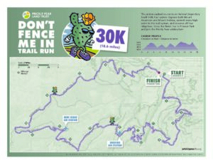
30K Course Description
The 30k starts at the intersection of Warren and Miller streets, a short walk from the event packet pick-up and porta-potties behind the Lewis & Clark Library past the S.S. Helena Memorial and through the tunnel under Cruse Avenue. The course begins by running south up Warren to Pine Street, turns left on Pine for a few blocks and right on Davis Street. It picks up the DeFord Trail and makes the second left turn onto the Eagle Scout Trail. After negotiating the switchbacks, the course continues east and makes a right turn onto the Pale Rider Trail, continues across the Easy Rider Trail and uphill onto the 2006 Trail. After several switchbacks, the course takes the left fork onto the Mt. Ascension Loop Trail, and then a right turn (up the ridge) when the trail hits the Mt. Ascension ridgeline.
This is the Entertainment Trail and it climbs steeply to the summit and proceeds along the ridge across another intermediate summit, down a short switchback section onto a very old two-track road and into some trees, keeping right at the trail junction. After a switchback, the trail makes a left turn downhill to the intersection with the Archery Range Trail. The course keeps left at the junction and continues down some switchbacks to Davis Gulch Road.
After a sharp right turn onto the Davis Gulch Road, a trail appears down the embankment to the left. The trail skirts the outside of the fence enclosing the Old Shooting Range (parking lot and trailhead) and begins a climb up some gentle switchbacks to Rodney Meadow. In the meadow, the course stays straight ahead past two right turns. Continue past the TR Trail for about 50 yards to a left turn onto the Roger Fuchs Trail. Stay on Roger Fuchs for about 50 yards to a right turn onto the Rent Money/Rodney Ridge Trail. This trail takes several switchbacks climbing to the junction with the Pinchot Trail. The connection from Rent Money to Pinchot is straight ahead, crossing the old Rodney Ridge Trail. The Pinchot Trail winds down the slope to intersect the TR Trail. Take a left turn on the TR Trail.
After winding downhill on the TR Trail, do not take the turn(s) onto the Waterline Trail—used only by the 12K. Continue down the TR Trail to come out on Orofino Gulch Road. The Orofino Gulch aid station is at the road crossing. Cross the road carefully!
Following course markings from the aid station, find the Evans Trail on the west side of Orofino Gulch Road. Take this trail, cross the bridge and follow it up to the ridge to an intersection with the Black Forest Trail. At this 4-way intersection, take a gentle left turn and follow the trail (Black Forest) across the meadow. It connects to the Wakina Sky Gulch Road. Turn left onto the road and continue on the road for about 100 yards. The Stairway to Heaven Trail veers up the slope to the right. Follow this trail up several long switchbacks to the ridge, keeping left at the first junction. Stay on the ridge to Wakina Sky Meadow, turn right on the Wakina Sky Trail (aka Goat) and continue west into the trees and many switchbacks down to Grizzly Gulch Road.
At Grizzly Gulch, the course makes a right turn (caution: no traffic control here) and follows the dirt road for about a quarter mile to the left turn onto Mini Ridge Trail. The Mini Ridge Aid Station is located here. Leave the aid station through a break in the fence and take another left turn about 15 yards past the fence line. This is the single-track E Trail. The trail winds through forest uphill to the Mt. Helena Ridge Trail. With a right turn onto the Ridge Trail, the course heads toward Mt. Helena, the highest point on the ridge ahead of you. STAY ON THE RIDGE! There are trails that branch off the ridge in both directions. DO NOT ABANDON THE RIDGE! The Mt. Helena Ridge Trail is the most direct trail route to the Mt. Helena summit. Follow the Ridge Trail (aka West End Trail) all the way to its junction with the 1906 Trail. Turn right and the 1906 Trail climbs to the summit of Mt. Helena.
After descending from the summit on the Hogback Ridge Trail and Prospect Shafts Trail the course drops into a field just above the houses of Reeder’s Village Subdivision. It takes a right onto a secondary trail that goes through a break in a fence, between two houses, and onto a paved road in the subdivision. Proceed with caution as there is no traffic control here. By keeping to the left on the first road and then veering right onto the second road, the course gets back onto a trail that again passes between two houses. It descends across a paved cul de sac angling to the left onto a few more yards of dirt trail and then onto pavement that goes under the Howie Street bridge. The course makes a right turn onto the bricks of historic Reeder’s Alley and crosses Park Avenue to the finish line.
Aid Station Cut-Off Times
As a consideration to our course volunteers, we will enforce cut-off times at the aid station. The cut-off times are 10 AM (2.5 hours race time) at the Oro Fino Aid Station, and 11:30 AM (4 hours race time) at the Mini Ridge Aid Station. If you do not reach the aid stations by those times, the volunteers will ask you to drop from the race. They will do their best to provide transportation back to the finish line.
Running: ~ 4 hours